Mini-Holland update – Part 2 – Making Kingston & Cambridge Roads safer

This is the second in a three part series on the Mini-Holland programme in Kingston. The Mini-Holland (or Go Cycle) projects are designed to provide safer and more accessible cycling (and walking) paths along a number of roads across the Borough of Kingston. This post looks at the proposals to make Kingston and Cambridge Roads, which link Kingston to New Malden, safer. The previous post looked at the Mini Holland schemes constructed in 2019. The final post in this series will look at what could come next after the Mini-Holland programme comes to an end.

Part 2 – Making Kingston/Cambridge Roads safer

One of the key features of the Mini Holland programme is to make key roads across the Borough of Kingston safer and more convenient for cycling (with measures added to benefit walking at the same too).

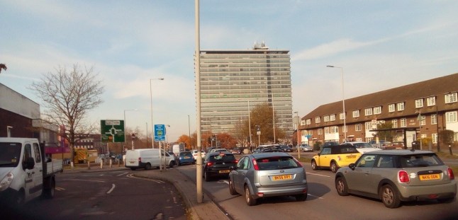
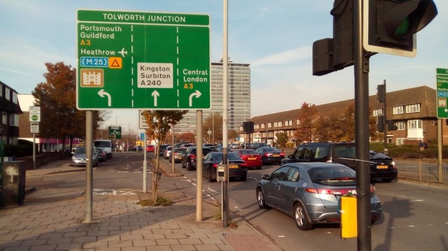
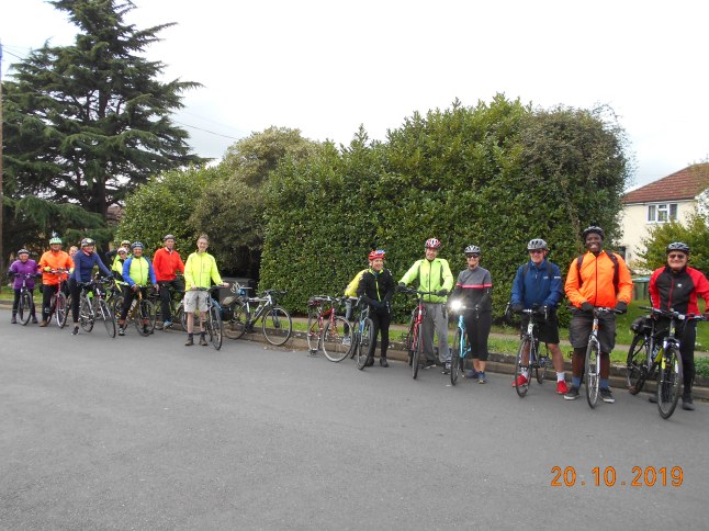
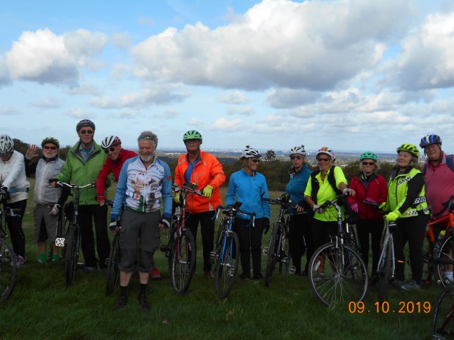
A number of Mini Holland schemes are already complete including Portsmouth Road and Kingston High Street where the number of people cycling has significantly increased since improvements were completed. Construction is currently taking place between Kingston and Kingston Vale (along Kingston Hill) and has also recently commenced between Kingston and Tolworth (along Ewell Road). A direct Cycleway from Kingston to New Malden has also been proposed and is the subject of this post. This route would be along Kingston and Cambridge Roads linking to the new 2-way cycle track recently constructed on London Road.

CamRd Map

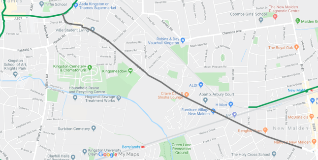
Map of the proposed Kingston to New Malden Mini Holland route (marked in grey; existing Mini Holland routes and Cycleways are marked in green)

What is proposed for the Kingston to New Malden route?

The proposed cycling and walking improvements will connect at one end to the Kingston Vale Cycleway (along London Road) joining the route to Wheatfield Way for direct connections to Kingston Station; Kingston town centre; and Surbiton. At its other end, the proposed improvements will reach New Malden and the edge of Cycleway 31 for a direct, mainly off-road, path to Raynes Park.

Along Kingston and Cambridge roads it is proposed that there will be:

  • A 2-way segregated cycle track along Cambridge Road between London Road and Hawks Road junctions
  • A 1-way segregated cycle track on both sides of the road along Cambridge Road (from Hawks Road junction) and Kingston Road to just after the junction with Connaught Road
  • Improvements at side roads to make it safer for people cycling and people walking by introducing measures to reduce vehicle entry and exit speeds as well as providing priority to those cycling across the junction and, in many cases, providing priority to people walking across them too
  • Improvements at signalised crossings to allow people cycling easier access to nearby destinations

Space for the new cycle track, and better crossings for pedestrians, will come primarily from the carriageway space currently used by motor traffic. In many parts of the road, it is already wide enough for a segregated cycle lane to be built and therefore bolt-down kerbs cycle segregation kerbs may be used like the ones recently introduced on Kingston Hill. In other places there will be some changes to kerb locations; parking; loading; and bus lanes to make room for the upgrades. We understand that Kingston Council has been working closely with Transport for London to minimise any disruption on bus journeys as well as speaking to local businesses to maintain loading and parking access.

IMG_20190901_114346

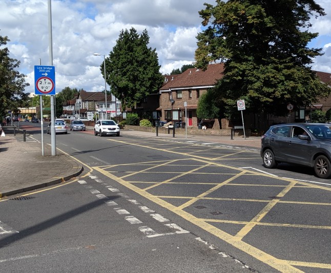
Current Kingston Road, New Malden. Advisory cycle lane markings have been heavily worn by passing motor traffic with no form of segregation for cyclists and no clear priority over side roads for pedestrians

Why are these improvements needed?

Unfortunately both Kingston and Cambridge Roads have been the location of many collisions causing injury to people cycling and walking. There have been over 120 people walking or cycling reported to have been injured (as well as one death) between 2005 and 2017 along the route following a collision with one or more motor vehicles.

CamRdCollisionMap

A map showing locations of reported collisions injuring (or killing) a person walking or cycling along the proposed Kingston to New Malden route from 2005-2017 Source: cyclestreets.net

This map does not include any collisions not reported and therefore the number of injuries along the route is unfortunately likely to be even higher. The Mayor of London is rightly targeting ‘Vision Zero’ (the aim for there to be no deaths or serious injuries on London’s road network by 2041). To achieve this aim, something needs to be done to make these roads safer for vulnerable road users.

Why should we be encouraging more cycling and walking?

Kingston already faces motor traffic congestion particularly at peak times. As the Borough grows, this could get even worse. However, cycling and walking are very efficient modes of transport with people cycling and walking taking up much less room than a person taking a car to their destination. By getting more people to walk and cycle, this can reduce congestion on the Borough’s roads.

Cycling and walking are also very sustainable methods of transport as they don’t require any petrol or diesel to get the person to their destination. As the Borough of Kingston has declared a Climate Emergency, it is more important than ever that people switch to sustainable methods of transport. However, they will only do this if they feel safe using them!

The other benefit of switching away from petrol or diesel powered vehicles is the improvement to air pollution this brings. Kingston has a number of issues with the amount of air pollution in the Borough. With walking and cycling producing close to no air pollution at their source these ways of travelling should be encouraged to reduce the level of air pollution that the Borough suffers. Even electric cars produce substantial amounts of air pollution through tyre and brake wear.

What are our thoughts on the proposals?

We are really excited by the proposals for Kingston and Cambridge Road. Whilst not perfect (for example, we would like loading on certain parts of the route to be restricted), the proposals will be a huge upgrade on the current sub-standard and dangerous cycling and walking facilities on the route. These improvements will make people feel safer, it will calm the environment and will encourage more people to walk and cycle in the area.

Subject to the outline plans being approved, we will continue to work with Kingston Council as they progress to the detailed design stage. We have already successfully campaigned for some changes to the plans which will benefit people cycling (and walking) and we will continue to campaign to get the best possible cycle infrastructure for the route.

Next steps

The proposals to make Kingston and Cambridge Roads safer are due to go to Council Committee for approval on 11 February. We will continue to strongly support the proposals to make this road safer for all road users and hope local Councillors will too.

The Kingston to New Malden Cycleway is the final Mini Holland scheme proposed. After this has been completed, the Mini Holland programme will come to an end.

11 February 2020 updateKingston Council approved the construction of the Kingston to New Malden Cycleway. Construction could start in Summer 2020 subject to final TfL approval and completion of detailed design.

What about the rest of the Borough?

There are many parts of Kingston Borough that will not be next to a Mini Holland route and people will therefore continue to be put off cycling (and walking) if the local road network is not made safe for them to use. The final part of our series on Mini Holland will therefore look at what could come next after the Mini Holland schemes have been completed.

In the meantime, if you are local to Kingston and Cambridge roads and would like them to be made safer, why not contact your local councillor to let them know?

Tolworth Traffic Turmoil

Have you heard? Transport for London (TfL) is proposing big changes to Tolworth Roundabout.

You may be forgiven for thinking that TfL and the Mayor of London are all about reducing motor traffic levels, improving air quality, promoting walking, cycling and use of public transport these days. Unfortunately you wouldn’t know it looking at the description and drawings of what’s proposed between Tolworth Broadway and Tolworth railway station.

What’s proposed?

TfL, after “working closely” with Kingston council, is planning to build an additional lane for motor traffic on the northbound approach to Tolworth Roundabout (i.e. for traffic coming from the direction of Epsom). This requires closing a pedestrian subway which some people prefer to the existing signal crossing, and the felling of a mature tree outside the Hollywood Bowl.

Tolworth Tower Traffic

An extra lane for motor traffic will be added here taking some of the forecourt from Hollywood Bowl which will require the removal of a mature tree

What are the reasons given for this scheme?

TfL say that if nothing is done to address the problem of traffic queues resulting from additional traffic then delays to buses will increase by up to 20 minutes in the peak. But why does TfL only mention buses in its consultation? Providing for private traffic doesn’t fit with TfL’s much publicised agenda, but that is in fact what it plans to do.

The consultation web page is very light on information so we requested more from TfL.

We asked TfL:

How much additional traffic is expected? Please provide information on how this “expected increase” has been arrived at and whether the figure and the predicted journey time saving would also apply to general traffic as well as buses.

TfL responded:

Developments in the area are predicted to add 750 jobs and 1300 new homes within the next five years. This growth will result in an increase in up to 400 vehicle trips in both morning and evening peaks.

Applying these extra trips to our modelling software, it is estimated that there will be up to 5% traffic growth in the area. This accounts for the planned vehicle parking spaces and predicted servicing requirements.

This method of calculating future traffic increase is standard practise for developments in London. The Tolworth Roundabout scheme proposes to improve journey times for general traffic as well as for buses.

Due to committed developments at Tolworth, journey times are predicted to increase by 20 minutes, if we do nothing.

 Our proposed scheme will provide significant improvements to the area and reduce the predicted increased journey times of 20 minutes by 11 minutes, resulting in a net increase of 9 minutes caused by developments.

So it looks like the plan is to provide space for the increased motor traffic rather than manage the demand?

It looks very much so. TfL are saying a 5% increase in motor traffic will result in increased delays of 20 minutes which can be managed down to an increase of 9 minutes.  All the capacity for car parking at the new Lidl headquarters and on the Tolworth development site mean that the car has to be accommodated it seems. There are no plans for a bus lane or improved bus facilities or a continuous cycle route on the station side of the A240 Kingston Road.

Tolworth roundabout sign

The proposals add an additional left turn lane towards the A3 here with no bus priority measures added. The central reservation will be widened to provide a shared use cycle and footway but only to Tolworth station and not beyond

No thought given to a continuous cycle route…

Disappointingly, and despite proposing to spend millions of pounds on this scheme, no thought has apparently been given to linking Tolworth Broadway to the new Lidl national HQ being built at Jubilee Way or to the proposed new cycle track on Jubilee Way itself, which would link Tolworth to Ewell and Chessington via an off-road track. Frustratingly, TfL appear to propose to do nothing about the “Cyclists Dismount” section in front of Tolworth railway station and under the railway bridge.  There’s a two-way cycle track on the south side of the railway that was built in the 1930’s and it needs to be joined to the Tolworth Greenway with a continuous cycle path. TfL’s suggestion is that cyclists should cross the A240 twice, using the path on the opposite side from the station and Jubilee Way.

Cyclists Dismount

Cyclists dismount sign by Tolworth Station. The proposals do not address a 50m gap in the cycle route towards Jubilee Way and Chessington and therefore this sign will remain

Read the consultation and provide your feedback here

TfL’s consultation page can be found here:  https://consultations.tfl.gov.uk/roads/tolworth-roundabout/ 

The consultation closes on 5th January 2020.  We invite you to tell TfL what you think the implications are of simply providing for more road traffic and ignoring cycle routes.

We’ll be strongly objecting to the proposals overall which will encourage motor traffic in the surrounding area. We will ask TfL instead to focus on improving public transport as well as walking and cycling routes. In particular, the short gap in the cycle track between Jubilee Way and Tolworth Station must be fixed.

Mini-Holland update – Part 1 – A review of 2019

This is the first in a three part series on the Mini-Holland programme in Kingston. The Mini-Holland (or Go Cycle) projects are designed to provide safer and more accessible cycling (and walking) routes along a number of roads across Kingston Borough. This post looks at what was achieved in 2019. The next in the series will look at the proposed Kingston to New Malden route and the final post will look at what could come next after the Mini-Holland programme comes to an end.

Part 1 – A review of 2019

After all that was achieved in 2018, what has happened in 2019?

New Malden to Raynes Park

The main event of the Mini-Holland programme this year was the opening of the excellent New Malden to Raynes Park cycle and walking link. This completely new route which mostly follows the train line between the two locations has opened up new opportunities for travelling between the two neighbouring areas. We are delighted that our campaign to get separate cycle and walking paths (rather than a shared path) was successful. You can find further information on the route in our post marking the opening of this new link. The new route has been named Cycleway 31. Cycleways are Transport for London’s new branding for cycle routes across London and this signage will be rolled out to existing routes such as Portsmouth Road too.

Penrhyn Road

The first phase of the Kingston to Tolworth route started construction earlier this year and is now almost complete with resurfacing and signage to follow early in 2020. The first phase of the route links the Wheatfield Way Mini-Holland scheme at College Roundabout to Surbiton Crescent using a 2-way segregated cycle track for the majority of its length. We worked with the Council to extend the amount of segregation from the original plans wherever this was feasible.

We are discussing with the Council possible locations for additional cycle parking along the route (some more are already planned next to the Surbiton Road parade of shops) so let us know if you have any suggestions for locations.

The second phase of the scheme along Ewell Road will start early in 2020 and will transform a road for cycling whilst improving facilities for people on foot too. Unfortunately, in recent years the road has been the location of many collisions causing injuries to people on bikes and people walking so it is great news that work to make it safer will commence soon.

Kingston Station

Following completion of the enlarged Station plaza, work has been taking place on the widened pedestrian and cycle bridge over Kingsgate Road which was lifted into place earlier this year. Work has recently commenced on the new cycle storage hub next to Kingston Station which will have space for at least 200 bikes. We are discussing with the Council how the facility will be monitored and maintained.

Work has recently taken place near Kingston Bridge as the crossing over Horse Fair is upgraded as well as a new cycle and pedestrian crossing being built over Clarence Street. Work will recommence in the new year after the Christmas break. When finished, there will be additional cycle stands in this very popular area for cycle parking.

IMG_20191207_193931.jpg

New cycle storage hub being built next to Kingston station

Kingston Vale

Construction on the Kingston Vale route started during Winter 2018/19 and the route is now almost complete between Galsworthy Road and Derwent Avenue. This route saw a new type of cycle segregation kerb used which bolts into the carriageway surface. This allows large amounts of cycle segregation to be provided at a much lower cost than a stepped (raised) cycle track.

Work has recently being taken place on London Road as signalised junctions are upgraded to provide separate signal stages for people on bikes as well as providing space away from cars, buses and lorries. Work will continue on this route in early 2020 (from Manorgate roundabout to Galsworthy Road) with it due to be fully complete by Summer 2020.

Wheatfield Way

This route between Kingston Station and College roundabout (linking to the first phase of the Kingston to Tolworth scheme, above) also finished this year. This route has new 3m wide segregated cycle tracks although we were unsuccessful in our campaign for cycle segregation across all the junctions on the route. This means that people on bikes share junction areas with people walking. We continue to campaign for better signage and wayfinding at these junctions to improve the usability of the route.

IMG_20190706_120932 (1)

Wheatfield Way segregated cycle track with shared use areas at junctions

Next steps

There is a lot of work to do in 2020 to finish off the schemes currently in construction although the majority of work in Kingston Town Centre has now finished. 2020 should see the completion of the Kingston Station scheme (and the opening of the Cycle storage hub); the completion of the Kingston to Kingston Vale route; construction commencing on Ewell Road on phase 2 of the Kingston to Tolworth scheme as well as small improvements to existing routes as ‘snagging’ items are fixed by contractors. Signage should also be installed on some of the new routes which will be key to helping people find and enjoy the new routes.

We speak to the Council regularly to highlight areas we think are good on the Mini Holland schemes as well as areas that we think need improvement. Please get in touch with us if you have any comments on the schemes that have been built or which are in construction.

Anything else? We hope that the Kingston to New Malden route along Cambridge and Kingston Roads will be approved for final design and construction in the new year by Kingston Council and TfL. We have seen how popular the new routes are when completed (see Portsmouth Road and New Malden to Raynes Park) and that they can both be safer for people walking and cycling as well as encouraging a switch to sustainable transport. Part 2 of this series will look at the plans for the Kingston to New Malden route to show why improvements are needed there too.

Further reading

The Council’s Go Cycle website

Our map of Mini Holland routes open, in construction and proposed

Our guide to new cycle infrastructure in Kingston

Our other Mini-Holland updates published during 2019:

  1. Mini-Holland (Go Cycle) – 2019 plans
  2. Mini-Holland (Go Cycle) – March 2019 update
  3. New Malden to Raynes Park route opening Sat 13 July 2019
  4. New Malden to Raynes Park cycle and walking paths – now open!
  5. Mini-Holland (Go Cycle) – September 2019 update
  6. Horse Fair crossing changes: September to November 2019

Midweek ride to Northolt

DSCN0384

Clock Tower, Northolt

Wednesday 11th December. A largely bright, chilly day, with a short shower of drizzle in the afternoon, saw 11 Cyclists leave via Kingston Bridge, Bushy Park, Fulwell, a short stretch of River Crane path, Whitton, Worton, Osterley, Osterley Park, Norwood green, Southall to Northolt, passing the lunch venue to see the Clocktower, (Photo), returning to ‘the Crown’, for lunch, after a slight delay for 1 person having 3, yes Three course’s, then a short stretch of brand new Tarmac on the Grand union Canal towpath, Greenford, Drayton green, West Ealing, South Ealing & Cemetery, Brentford, -a strategic vote elected for a short cut-, Kew Bridge, Richmond, Richmond Hill, Richmond Park to Pembroke lodge Cafe for Tea & Cakes, Kingston Gate, -with a small pause for the tail end, taking an alternate route-, to finish at the Market place. Total 29 Miles, thanks to John E for back marking, & others for marking corners, 1 new face.

Map:-www.plotaroute.com/route/983472

Christmas special ride to New Malden

DSCN0382

Wimbledon Common & Windmill

Sunday 8th December, a bright pleasant Morning saw 23 Cyclists have a slightly delayed start, due to the late running of Trains, leave via Skerne Rd, Kingston gate Richmond Park, White lodge, Roehampton gate, Roehampton, Wimbledon Common, (Photo), Westside, Raynes park, New Malden to Woodies, for a superb lunch,

20191208_125424

Lunch at Woodies

including a few others who managed to find the venue by other means, after thank-you speech’s from Bai to the ‘leadership team’, also the Back markers, from Ride leader Roger, to Mike for deputizing on occasion, reiterating thanks to all the Back markers & corner markers, for all there hard work, & especially the Pub for Catering so wonderfully, then the presentation for assistant of the Year to Ellie for Back marking & other help as needed, finally Ride organiser, John announced the Prize for the best attendance, went to Rob W, a slightly Cooler afternoon, with light Drizzle….., soon turning gradually heavier and with a Cold brisk Wind, to Freezing Rain via Motspur park, Worcester park, Stoneleigh, West Ewell, -the Rain finally ceasing, also displaying a good Rainbow-, Chessington, to Long Ditton for Tea & Bread pudding, Surbiton, to finish at Kingston. Total 23 Miles, Thanks to Ian for Back marking, & many others for marking corners, thanks to John D for the BP.

Map:-www.plotaroute.com/route/962880

2 part ride to Epsom & Twickenham

DSCN0379

New Malden to Raynes Park path

Sunday 17th November, Part 1. A mostly bright morning saw 21 Cyclists leave via Fairfield, -with 1 minor navigational hiccup-, Bonner Hill, Norbiton, New Malden, (Photo), Raynes park, Lower Morden, Worcester park, Stoneleigh, Ewell village, to Epsom, for lunch at ‘the Assembly rooms’, (Wetherspoons), West Ewell, Tolworth, King Charles Bridge, to Kingston. Sub total 20 Miles, thanks to Ellie & Lars for back marking, and many others for marking corners, especially Ken, for bringing the group back together, 2 new faces.

Map:- www.plotaroute.com/route/970863

Part 2, with Cloudier Skies, saying farewell to 18 & welcoming 2 fresh faces, just 5 Cyclists left via Skerne Road, Lower Ham Rd, Thames path, Aerospace estate, Ham, more Thames path, Richmond, Richmond Bridge, St Margerets, River Crane path, Twickenham to Squires Garden centre for Tea & Bread pudding, Fulwell, Bushy Park, Hampton Wick and Kingston Bridge. Sub total 11 Miles, Total 31 Miles, Thanks to Steve J for back marking, thanks to John D for the BP.

Map:- www.plotaroute.com/route/971599

Midweek ride to Staines

DSCN0378

Bushy Park

Wednesday 13th November. A very Sunny Morning, with a cloudy afternoon, saw 14 Cyclists leave via Cranes park, (anyone spot the ‘loose Pig’, hindering Thames Water, trying to repair a burst water main ? 🙂) King Charles Bridge, Surbiton, Long Ditton, Hinchley wood, Littleworth Common, Esher, Walton, Walton Bridge, Shepperton, Laleham, Thames Towpath to Staines for lunch at ‘the Wheatsheaf & Pigeon, then, finding the ‘P fairy’ had paid another visit, swiftly repaired, onto Ashford, Feltham, Hanworth, Hampton hill, Bushy Park, (Photo), to ‘the Pheasantry cafe for Tea & refreshments, Hampton Wick, Kingston Bridge. Total 28 Miles, thanks to Steve D for back marking, and others for marking corners, 1 visit from the ‘P fairy’.

Map:- www.plotaroute.com/route/967836

Bread pudding ride to Wraysbury

DSCN0376

River Mole near Esher

Sunday 3rd November, a bright start, with increasing Clouds & 1 or 2 very light Misty showers saw 25 Cyclists leave via Kingston Bridge, Bushy Park, Hampton, Hanworth, Feltham, Bedfont, Stanwell, Stanwell moor, Poyle, to Wraysbury for lunch at ‘the Perseverence’ about to leave the Leader finds the ‘P fairy has paid a visit,- maybe because he had been a bit Jocular about the Pub name before the start-, after several minutes of fruitless grunting & heaving, still unable to remove the Tyre from the Rim, it was felt prudent for the main group to proceed with a fresh leader, meanwhile assisted by Rob, with a bit of fruity language, & more perseverence, finally the Tyre was off, to find it wasn’t a ‘Tubeless Tyre after all, although stuck to the Rim in a similar fashion, still more fun removing the thorn, refitted with a new tube, could we catch the main group before Tea ? Via Hythe end, Staines, -with a small section heading for the Train, including our Back marker-, Thames towpath, Penton Hook, Laleham, a couple of fleeting glimpse’s, that might be, no not in Laleham, had they stayed on the Towpath, following the Thames towards Chertsey Bridge, Yes, there they are, Shepperton, -with the 2nd visit from the ‘P fairy’-, Walton Bridge to Gino’s Cafe for Tea & Bread Pudding, Walton, yet another visit from you know who, Esher, Weston Green, Giggshill Green, & yet again a 4th visit from the ‘P fairy’,(all different victims), Portsmouth Rd to Kingston. Total 32 Miles, thanks to Will, Jon W &  Andrea for Back marking duties, & others for marking corners, thanks to Mike F for filling in as Leader, thanks to John D for the BP, special thanks to Jon W for assisting with repairs. Anyone with influence, please have a word with the right god’s to resume only occasional visit’s from the P fairy, 😉

Map:- www.plotaroute.com/route/707341

Bread pudding ride to Little Bookham

DSCN0370

Long Ditton

Sunday 20th October, a largely Sunny morning, with grey clouds in the Afternoon, saw 28 Cyclists leave via, Lower Marsh, Berrylands, Tolworth & greenway, West Ewell, Hogsmill path, Long grove Park, Ashtead Common, Leatherhead, Fetcham, Bookham to Little Bookham for lunch at ‘Ye olde Windsor Castle’,- with a select few opting to visit the ‘Vineries Garden centre Cafe’-, re-gathering, Effingham, Martyr’s Green, Hatchford, Cobham, the Fairmile estate, Portsmouth Rd to Claremont Lake Cafe, (NT) for Tea & Bread pudding, Esher, Hinchley wood, Long Ditton, (belated Photo), Surbiton, a brief look at the Surbiton Rd & Penrhyn Rd works, to Kingston. Total 29 Miles, 4 new Faces, thanks to Mike for back marking, & many others for marking corners, thanks to John D for the BP.

Map:-www.plotaroute.com/route/954549

Midweek ride to Woodmansterne

DSCN0366

the London Skyline, from Epsom Downs Credit: Rob R

Wednesday 9th October. A mostly bright day saw 16 Cyclists leave via Lower Marsh, Berrylands, Tolworth & the greenway, West Ewell, a brief part of the Hogsmill path, Epsom, Epsom downs, (Photo), -with a small tumble leading to a slight ‘exposé’, luckily for the victim, the Camara didn’t record the event 😉,-Tattenham corner, Burgh Heath, Banstead, to Woodmansterne for lunch at ‘the Woodman’, then Wallington, Beddington Park, Hackbridge, the Wandle trail, Morden, to Morden hall Park, for Tea & refreshments, then Merton park, Wimbledon Chase, Raynes park, New Malden, Norbiton, to Kingston. Total 28 Miles, 1 new face, thanks to Pete S for back marking, & others for marking corners.

Map:-https://www.plotaroute.com/route/945357