So here we go again! Kingston Station is at the heart of Kingston’s cycling network. It’s where the main routes from Wheatfield Way and nearby Old London Road converge, as well as other bike routes to the town centre, the riverside, and north along Richmond Road. But only a hundred metres away, a revised planning application has been submitted to rip out the existing protected bike lane on Richmond Road. So what’s going on?
Kingston Gate is a proposed development, building over a car park and an adjacent busy road. The developers propose diverting this traffic onto Richmond Road, but they want to remove the protected bike lane in order to do so. This will completely sever this route, and their proposed cycling diversion on the pavement and around the back of the shops is a waste of time.
If this seems familiar, it’s because the same developers proposed something similar in 2021. But this time there’s no phase 2 proposed, no reinstatement of the bike lane at any point in the future, and so removing this protected bike lane will be permanent.
This has to be stopped before it gets started, or we will lose this route forever. Richmond Road is a key cycling artery, both now and for the future. The council should be providing protected space for southbound cycling, never mind retaining the northbound protected route. The Council’s own plans are to upgrade the cycling route all along Richmond Road, and earlier this month they applied to TfL for millions of pounds of funding to do so. But this planning application will ruin it all, if it goes ahead.
It’s not too late for the developers to change their proposals, or for the council to reject them. But for this to happen we need your support.
How to Object
Kingston Cycling Campaign have already submitted our detailed objection to this scheme – covering much more than the problems covered here. But the best way to ensure this route is kept is for everyone to add your own objections – we know from experience that the more objections, the more weight is given to them.
If you objected in 2021, please also object again today!
Visit the application on the council’s website: 19/02323/FUL
Fill in the form, and pick “Object” as your stance
Tick “Access or traffic problems”
In the comment, say that you object to the proposal on the grounds of Road Safety, that you object to the removal of the protected bike lane on Richmond Road, and you object to there being no consideration of a southbound protected bike lane being added at any stage of the project or in the future.
Note that comments have to be submitted by the end of Tuesday 26th November 2024 – so please take a minute and submit yours right now!
Whilst the network of Kingston’s new Cycleways delivered as part of the Council’s ‘Go Cycle’ project is far from complete, it’s interesting to see the large number of people who are using the parts of the network already completed.
Although we see lots of people using the network on a daily basis, it is always interesting to have a look at real data to determine actual usage and look for any trends that can be spotted. We have therefore compiled some data from the Council’s existing Cycle Surveys as well as some more recent data produced from Vivacity traffic counting monitors which Kingston Council has been trialling and which we’ve received limited access to.
So, what does the data show us?
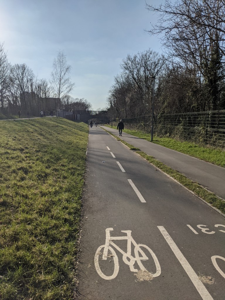
New Malden to Raynes Park (Cycleway 31)
This excellent Go Cycle project created brand new walking and cycling paths alongside the South Western train mainline between New Malden station and Raynes Park recreation ground.
Kingston Council’s 2020 cycling survey stated that an average of 320 people were using this route for cycling each day. However, in 2021, The Vivacity sensor data trial shows that 542 people on average used it for cycling (between 14 May and 21 November 2021).
In addition to people using it for cycling, 703 trips by people walking have also been recorded on average each day. Given that before this route opened people couldn’t walk or cycle at all along this path, the data demonstrates how amazingly popular it has become in such a short amount of time.
The popular Beeline Way(Cycleway 31)
The popularity of the path is probably helped by it being away from roads meaning it has reduced air and noise pollution compared to alternative routes (for example, via Burlington Road).
Kingston to Kingston Vale (Cycleway 30)
This is the longest end to end Go Cycle project (4.5km) leading from the centre of Kingston to (almost) the Borough boundary with Wandsworth at the Robin Hood junction of the A3.
Despite construction being started in 2018, this Go Cycle route was only completed in full in early 2021 due to Covid related delays. However, parts of the route were open in 2020 and Kingston Council’s 2021 cycling survey stated the number of people using Kingston Hill for cycling was already increasing, with 363 people cycling on the route in 2020 compared to 211 in 2019 (noting that there had been a general increase in cycling in 2020 due to a national lockdown).
There isn’t a Vivacity sensor on Kingston Hill itself, but there is one on London Road near the end of the Go Cycle route by Tiffin School. This sensor shows an average of 1,521 cycling trips using the route a day (between 12 May and 21 November 2021). This compares with an average 15,467 cars being picked up by the sensor each day meaning, in the same year the route was completed, the number of cycle trips on this part of the route has already reached around 10% of the number of cars using the road!
The London Road section of the Kingston to Kingston Vale route (Cycleway 30)
Kingston to Surbiton (Cycleway 29)
This Cycleway was the second major road route to be completed as part of the Go Cycle programme (the first being Portsmouth Road). Unfortunately, this route suffers from many shared areas at junctions (where people cycling and walking mix in the same space), particularly along the Wheatfield Way part of the route. It therefore doesn’t provide direct, uninterrupted journeys for people cycling and its popularity as a cycling route is likely to be harmed as a result. Despite that, the Vivacity sensor on Wheatfield Way shows an average of 462 cycling trips on this part of the route per day (24 June to 21 November 2021) and 652 cycling trips on Penrhyn Road (6 May to 21 November 2021) based on a sensor near the Kingston University building.
A shared area section of Cycleway 29 at the junction of Wheatfield Way and Fairfield North
There is also a Cycleway ‘link’ route along Claremont Road towards Surbiton that connects to Cycleway 29 but isn’t the main Cycleway 29 route. The Claremont Road Cycleway is an indirect route as a decision was made to reroute the Cycleway around The Crescent rather than continuing it along the full length of Claremont Road (which would have required the removal of car parking spaces). The Vivacity sensor here recorded an average of 298 cycle trips per day (6 May to 21 November 2021).
The final Vivacity sensor we’ve seen data for on this route is on St Mark’s Hill though again, this is just a Cycleway ‘link’ and isn’t the main route for Cycleway 29. As with Claremont Road, due to the decision to keep car parking spaces, there is only a segregated cycle path on one side of the road (in the direction up the hill) reducing its popularity for people cycling. The Vivacity sensor here recorded an average of 359 cycle trips per day (6 May to 21 November 2021 (excluding 5 days in June where data recording appears to have failed)).
Surbiton to Kingston via Portsmouth Road (Cycleway 28)
This was the very first Go Cycle route to be built and was completed to a very high standard after Kingston Cycling Campaign successfully obtained improvements to the original plans.
This route features a two-way segregated cycle lane for most of its length and was extended in 2018 to take the two-way segregated cycle path along most of Kingston High Street (though unfortunately it does not yet reach the Ancient Market Place).
Sadly a Vivacity sensor has not been placed on this route so we need to look at data released as part of the Kingston Council Cycling Survey to look at numbers using this route. Helpfully, the 2021 survey provided average cycling figures for 2018-2020 (which we assume are from the automatic cycling counters the Council has installed on this road):
2018 – 1,068 people cycling per day
2019 – 1,114 people cycling per day
2020 – 1,582 people cycling per day
As the survey notes, during the middle part of 2020 there was a large increase in cycling following a national lockdown (the number of cycle trips peaked at 3,891 on a single day during 2020!) so it will be interesting to see if this has increase has been sustained on Portsmouth Road for 2021. In any case, it is great to see an increasing number of people using this safer cycle route.
Is there any other data available for this route? Well, the Department of Transport also compiles traffic counts and has one for Portsmouth Road. Looking at the Department of Transport’s figures we can see an actual (rather than estimated count) was last completed in 2016. Whilst this is a ‘spot count’ (it only counts people using the road on a single day rather than averaging it over a longer period), it shows that there were only 815 people counted cycling using the road on the day the count was taking place out of 15,424 total number of vehicles counted. Compared with that ‘spot day’ and the latest Kingston Council figures, cycling along the route has therefore almost doubled between 2016 and 2020.
As with the Kingston to Kingston Vale route, assuming the total number of vehicles using Portsmouth Road has remained broadly steady since 2016, the number of people cycling on the route could again be around 10% of the total vehicles using the road!
Portsmouth Road – Cycleway 28
Any other data?
Some other quick statistics:
1,370 walking or cycling trips on average per day across the new bridge taking people over the one-way system near Kingston Station (25 June to 21 November 2021 – Vivacity sensor data). Given this route was closed for over two years and only reopened earlier this year it’s already proving popular and allows for many more people to use it than the bridge it replaced.
421 cycling trips on average per day using the South Lane underpass to cross the A3. This is one of the few safe and convenient crossings of the A3 in this area (6 May to 21 November 2021 – Vivacity sensor data).
Only 394 cycling trips per day on average on Coombe Lane West (2 May to 21 November 2021 – Vivacity sensor data). This route was removed from the first phase of the Go Cycle programme and therefore lacks segregated cycling facilities. This is despite it being a major desire route for cycling between Norbiton and Raynes Park. It also passes a number of current (and planned) schools as well as Kingston Hospital. We hope that Kingston Council will be successful in their funding bid for Go Cycle phase 2 which provisionally includes this route. Coombe Lane West could then see an improvement in cycling rates as seen on the Go Cycle phase 1 routes already constructed.
More Department for Transport data suggests that, as mentioned earlier, there was a large increase in cycling nationally during the middle part of 2020 following a national lockdown. However, nationally, the data states that cycling levels in 2021 have broadly returned to those at the beginning of March 2020. The apparent increase in people cycling in Kingston during 2021 is therefore even more impressive.
What does all this data tell us?
It is important to emphasise that the Vivacity sensors are under trial and the figures used above have not been audited. However, the Vivacity sensors do seem to pick up a similar number of vehicles per day as shown in other recent Council traffic counts which use different technology. A trial of these sensors elsewhere in London also showed they were up to 97% accurate.
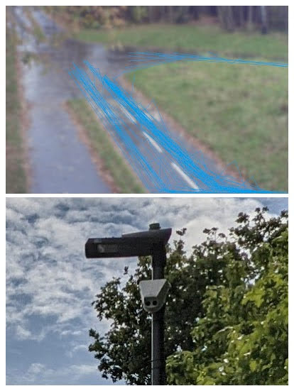
It is also interesting that the sensors can pick up ‘tracks’ of vehicles so can see what paths they are taking and which turns they make (see photo below). These images could help more easily determine the origin and destinations of journeys as well as helping understand whether people find the new cycling infrastructure useful or if they are avoiding it and are using the road instead.
Vivacity sensor image showing cycling ‘tracks’ along Beeline Way during a one hour period on 23 November 2021 and a picture of the sensor on a nearby lamppost
We look forward to hearing the results of the full trial of the Vivacity sensors and hope the Council will keep those in place on the Go Cycle network as well as filling in gaps in their coverage on the remainder of the network.
The data seems to show that the New Malden to Raynes Park has been very successful and also, that where there is continuous high-quality segregated cycle routes, e.g. Portsmouth Road and London Road, that cycling rates can be a substantial portion of the total number of vehicles using the route. However, where there are gaps in segregation for people cycling, for example Wheatfield Way, cycling rates seem to be lower. We therefore hope this data gives Kingston Council the drive to look at improving the continuity of exiting Cycle routes to provide direct and segregated routes, even through junctions.
Overall, the numbers of people cycling on the Go Cycle routes seem to be increasing. However, with Phase 1 of the Go Cycle network still not complete and Phase 2 currently unfunded, it will be some time before everyone in the Borough lives next to a safe cycling network. Until that happens, cycling levels in the Borough are unlikely to reach their full potential.
Kingston Station is at the heart of Kingston’s cycling network. It’s the site of a new multi-million pound cycle hub, the brand new Wheatfield Way and nearby Old London Road Mini-Holland routes, and other bike routes linking to the town centre and north along Richmond Road. But only a hundred metres away, a planning application has been submitted to rip out the existing protected bike lane. So what’s going on?
Kingston Gate is a proposed development, building over a car park and an adjacent busy road. The developers propose diverting this traffic onto Richmond Road, but they want to remove the bike lane in order to do so. This will completely sever this cycle route, and their proposed diversion on the pavement around the back of the shops for people cycling is a waste of time. In the second phase of development, they say, they will demolish this row of shops, and they say they will then put a northbound cycle path back in.
But there’s a real risk that Phase 2 won’t even happen. If Phase 1 goes ahead as planned, there is no obligation on the developers to apply for the permission required for Phase 2. Even if they do, there’s no obligation to actually construct it – planning applications go unbuilt for all kinds of reasons. And most worrying of all, they don’t even own any of the properties that would need be demolished for Phase 2 to go ahead. This means the supposedly temporary loss of the protected bike route would become permanent.
This has to be stopped before it gets started, or we could lose this route completely. The Council should be upgrading this route in the first place – it’s a key link in their existing plans, and they should be providing protected space for southbound cycling, never mind retaining the northbound protected route throughout any planned works. Richmond Road is a key cycling artery, both now and for the future.
It’s not too late for the developers to change their proposals, or for the council to reject them. But for this to happen we need your support.
How to Object
Kingston Cycling Campaign have already submitted our detailed objection to this scheme – covering much more than the problems covered here. But the best way to ensure this route is kept is for everyone to add your own objections – we know from experience that the more objections, the more weight is given to them.
Visit the application on the council’s website: 19/02323/FUL
Fill in the form, and pick “Object” as your stance
Tick “Access or traffic problems”
In the comment, say that you object to the proposal on the grounds of Road Safety, that you object to the removal of the protected bike lane on Richmond Road during any phase of construction, that you object to any reinstatement being dependent on subsequent phases which may not go ahead and you object to there being no consideration of a southbound protected bike lane being added at any stage of the project or in the future.
Note that comments have to be submitted by the end of Wednesday 21st April – so please take a minute and submit yours right now!
As we reach the end of 2020, we’ve taken a look at the progress that was made on Kingston’s Mini-Holland programme (also known as ‘Go Cycle’) during the year and finish with a look towards 2021.
Kingston to Kingston Vale
The Kingston to Kingston Vale cycle route is the longest in the Mini-Holland programme and started main construction in 2019. It was due to be finished this year but events of 2020 caused this timeline to become unachievable. Despite the difficulties of 2020, during the year the 2-way track along London Road between Queen Elizabeth Road and Manorgate Road was completed as well as the cycle tracks between Manorgate Road and Queen’s Road. Some ‘snagging’ (fixing minor issues) also took place on Kingston Hill and Kingston Vale on stretches of segregated cycle track constructed in 2019.
The reconstruction of the junction between Kingston Hill and Wolverton Avenue finished this year (new and before photos)Cycle tracks added to Kingston Hill (between Queen’s Road and Manorgate Road) finished this year (before and after photos)New 2-way cycle track along London Road completed this year
The only sections outstanding on this route are the junction of Kingston Hill with Queen’s Road and the separate junction with Galsworthy Road. These should be constructed in Spring 2021, and along with finishing the ‘snagging’ items, this will complete the 4.5km route from Kingston Town Centre all the way to the A3 which is close to the Borough of Kingston’s border with Wandsworth.
Surbiton to Tolworth
The Surbiton to Tolworth scheme along Ewell Road will link these two areas with a safer cycle route and started main construction at the beginning of 2020. The majority of the route was due to be completed by the end of the year. However, again timelines have changed and only Phase 1 was completed (St Mark’s Hill to Browns Road). Phase 2 (Brown’s Road to Tolworth Broadway) has had its plans tweaked to fit within a reduced budget provided by TfL and its construction could start early in 2021 subject to TfL’s final approval and funding. Phase 2 could then be completed in 2021 creating a safer cycle route from Tolworth all the way to Kingston Town Centre via Surbiton.
First phase of Surbiton to Tolworth cycle route along Ewell Road completed in 2020. Photos of new and prior layout.
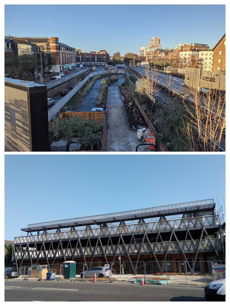
Kingston Station
Kingston Station is the ‘hub’ of the new Mini-Holland network of safer cycle routes and has seen a lot of associated construction activity in recent years. The main progress this year has been continued construction of the Kingston Station bike storage hub which will have space for 450 bikes as well as bike maintenance facilities, lockers as well as a space for a cafe.
Photos of the new cycle and walking bridge which will take people from Kingston Station towards the Thames and the new Kingston Station bike storage hub which will have capacity for up to 450 bikes
Next to the hub is a new bridge which is approaching its final stages prior to opening. This bridge will better link Kingston Station to the Thames and towards Ham. Together with the Low Traffic Neighbourhood along Lower Ham Road and the due to be completed Surbiton to Tolworth link, this will mean there is a 7km safer cycling route (almost!) all the way from the Borough of Kingston’s border with Richmond upon Thames (at Ham Cross) to its border with Epsom & Ewell (near Tolworth).
Both the bridge and bike storage hub should be open by the end of January 2021.
Anything else?
Right at the beginning of the year, the finishing touches were added to the Kingston to Surbiton route (along Penrhyn Road) though that feels a long time ago now…
Outside of the Mini-Holland programme, due to reduced funding and other obvious priorities, there were few infrastructure improvements to the Borough’s cycle network outside of the Mini-Holland (and Streetspace) programme. However, we were pleased that Kingston Council listened to our suggestion and found time to install a dropped kerb next to a ‘toucan crossing’ (for people cycling and walking) near Kingston Station to make it easier for people to get to/from the cycle path underneath Kingston Railway Bridge.
New dropped kerb near Kingston Station making it easier for people cycling to get to/from the cycle track under the railway bridge
Finally, the excellent and very popular New Malden to Raynes Park walking and cycling paths had its first birthday in 2020!
The future
As above, there are bits of the existing Mini-Holland programme to finish off which should be completed in 2021 with the main construction activity due to be along Ewell Road as the second phase of Surbiton to Tolworth is completed. This leaves the proposed Kingston to New Malden cycle route as the only scheme that would remain outstanding….
Kingston to New Malden is the final part of the Mini-Holland programme but is yet to start construction. We understand that this scheme is ready to start construction as soon as Spring 2021 (it received approval from Kingston Council at the beginning of 2020) but it is currently unfunded. We understand Kingston Council continue to lobby TfL for the funding to be provided but until this is happens, the final critical link in the Mini-Holland programme will remain unbuilt. This is despite large housing developments being built along the route as well as its dismal record for safety for people cycling and walking. We will continue to campaign for this vital cycle route and hope TfL will be able to fund it at some point in 2021.
As a final note, we would like to thank everyone involved in the Mini-Holland programme (designers; project managers; construction crews; cycle lane sweepers; Councillors; TfL sponsors; members of the public who have provided feedback; Kingston Cycle Campaign volunteers and many more) for their hard work and contributions during a very difficult year.
A few people from Kingston Cycling Campaign and Merton Cycling Campaign met on the New Malden to Raynes Park Cycleway this afternoon (socially distanced of course) to celebrate its first Birthday which is due tomorrow, 13 July 2020.
The New Malden to Raynes Park Cycleway
The New Malden to Raynes Park Cycleway (also referred to as ‘Cycleway 31’) has transformed cycling and walking between the two locations since it opened. It opened up previously underused Thames Water land allowing people to cycle and walk between the two locations in a safe environment for the first time. After our successful campaign, the Cycleway was built with separate walking and cycling paths (instead of a single shared path) reducing conflict for people using the route too.
This afternoon we counted over 130 people on bikes in just an hour using the Cycleway with over a third of these being children either cycling with family or friends. There were a similar number of people walking too. This level of usage clearly demonstrates the desire for safe cycle and walking routes.
We expect that this Cycleway would be even more popular if it connected to safe cycle infrastructure at both its ends. We therefore will continue to campaign for the construction of the Kingston to New Malden Cycleway along Cambridge and Kingston Roads.
The proposed Kingston to New Malden Cycleway would pass close to the beginning of the New Malden to Raynes Park Cycleway providing a safer link onto it. The Kingston to New Malden Cycleway was approved by Kingston Council earlier this year but currently does not have any source of funding to start construction. In the meantime, people will continue to be put off cycling on these busy and dangerous roads.