A summary of the group rides organised by Kingston Cycling Campaign in 2024 and a link to each of the routes so you can ride them at leisure! Click here for ride leader Roger’s review of the year.
Wednesday 11th December. A dull grey, chilly day saw 19 Cyclists split into 2 groups, leave via Lower Marsh, Berrylands- group 2 collecting 1 more-, New Malden, Motspur park, Lower Morden, Morden, South Wimbledon, Wandle trail, Earlsfield, Wandsworth Common, Clapham Common, to Battersea for lunch at the Asparagus (Portobello pubs), – now just 1 group, as a few have departed-, a bit more Battersea, Thames Path, Wandsworth Park, Putney, Barnes Common, to East Sheen for Tea & refreshments at Palewell Common Cafe, Sheen gate Richmond Park, Ham gate, Ham, Canbury Gardens, to finish back in Kingston. Total 27 Miles, thanks to Steve D & Toni for back marking each group, also thanks to John E for back marking after Tea. Apologies, no Photo this time. Map:- www.plotaroute.com/route/2826090
Sunday 8th December. With ‘storm Darragh’ still blowing through the area, it was wise to advise all to go straight to the lunch venue, but amazingly a total of 11 Cyclists, either didn’t read the message, or decided to ride regardless, after a brief discussion, a decision was made, so via Portsmouth Rd, to Surbiton for an impromptu Coffee stop at the Clocktower Cafe, then a tour of Berrylands & Tolworth, to Thames Diitton for a delicious lunch at the ‘Limping Fox’, joined by another 23 or was it 24 Cyclists (some with Bikes, some without), after thank-you speeches from Bai, & a response from myself, with 2 prizes this time, for Bai with all his co-leading & Celia for her cheerful back marking, sometimes with really nasty Weather, now with steady drizzle & time getting short, 3 more joined the return trip back to Kingston. Total 8.5 Miles Cycled, special thanks to Celia for back marking. Map:- www.plotaroute.com/route/2823884
Sunday 24th November, Part 1. A very blustery windy day, not a surprise than 8 people cancelled, just 4 left the Market via Lower Marsh, Berrylands- to find 1 more unexpected guest waiting, (now 5)-, New Malden, Motspur park, North Cheam, Cheam Park (Photo), Nonsuch Park, Stoneleigh, West Ewell, a little bit of the Bonesgate path, to Chessington for lunch at a very hospitable William Bourne (Stonegate Pubs), back on the Bonesgate path,, Tolworth, Surbiton, to finish back in Kingston. Sub-total 16 Miles, very special thanks to Bai for leading part 1, thanks to Neil for back marking. Map:- www.plotaroute.com/route/2806965
Part 2 Still very windy, so farewell to 1, & welcome 3 fresh faces, 7 Cyclists left into a strong headwind, on Portsmouth Rd, Giggshill Green, Weston Green, Esher, Walton- a new 2 way cycle lane in the town centre-, Walton Bridge, Shepperton, Haliford, to Sunbury, just in time for Tea & refreshments at the Walled Garden, more Sunbury, Hampton, to find the management of Bushy Park had decided to keep it closed all day, so a detour via Teddington, Hampton Wick, Kingston Bridge, to finish back in Kingston. Sub-total 16 Miles, Total 32 Miles, thanks to John E for back marking. Sorry no Pic for part 2. Map:- www.plotaroute.com/route/924654
Wednesday 13th November. A bright day, with some Sun, after 1 late cancellation, saw 15 Cyclists leave the Christmas Market place, via Skerne Road, Latchmere, Ham gate Richmond Park, White lodge, Roehampton gate, Barnes Common, Putney, Putney Bridge, Parsons Green, Brompton Cemetery, South Kensington, Kennsington Gardens, Bayswater, to view an odd House or 2, Paddington, to view an ‘arty Clock’ & a few ‘Animals’ enjoying lunch- sort of-, a rather congested with traffic Marylebone, to Maida Vale for lunch at the Carlton Tavern, Kilburn, North Kensington, Shepherds bush, Hammersmith to Ravenscourt Park for refreshments at the recently refurbished Paddenswick Tea Gardens, Cycleway 9, Chiswick, Grove park, Chiswick Bridge, Mortlake, Sheen gate Richmond Park, Kingston gate, to finish back in Kingston. Total 29 Miles, thanks to Dave P for back marking & others for marking corners. Map:- www.plotaroute.com/route/2162317
Sunday 10th November. A cloudy grey day, with light Mizzle (misty Drizzle), with 1 late cancellation, 1 forced to abandon the ride due to a defective brake, 1 extra guest, who had mistakenly booked on a different event, 20 Cyclists split into 2 groups, group 1 not quite ready, so group 2 led the way via Kingston Bridge, Bushy Park, Hampton, to Hanworth to pause at the War Memorial for the 2 minute silence, -but as they were in the midst of a longer service, sadly no chance for Andrea to read from Laurence Binyon’s ‘For the Fallen’-, Sunbury, Ashford, Staines, Staines Bridge, Egham, Stroude, to Thorpe Green (Photo group 1), for lunch at the Rose & Crown (Barons Pubs), – very speedy service, with great food & drink, (Photo group 2), alas 1 of group 1 had a visit from the ‘P fairy, despite a slightly confused assistant, who got the Tube’s mixed up, soon fixed-, continuing via Lyne, Bretlands, Addlestone, Weybridge, to Walton Bridge for refreshments at ‘Wilde Brunch’- joined by 1 more (21)-, Walton, Esher, Weston Green, Giggshill Green, Portsmouth Rd, to finish back in Kingston. Total 30 Miles, 1 new face, special thanks to Bai for leading group 2, thanks to Celia & Amy for back marking each group. Map:- www.plotaroute.com/route/2802886
Sunday 27th October, with the clocks having returned to GMT, a bright Sunny day saw 20 Cyclists split into 2 groups, -alas about to depart, 1 of group 1 found a flat, thus a change of groups, 2 became 1 & vice versa-, leave via Raynes park, Wimbledon Chase- sadly 1 of group 1 had a tumble, a couple of bruises, but quite shaken, decided to head for home-, South Wimbledon, Colliers wood, Tooting- joined by 1 more for group 1-, Tooting Bec Common, Streatham Hill, Brockwell Park, (Photo group 2), Dulwich, Dulwich Park (Photo group 1), Peckham Rye Park, Nunhead, to Brockley for lunch at the Brockley Barge (Wetherspoons), a bit more Brockley, then Ladywell fields to join Waterlink way, via Catford, Sydenham, & Cator Park, then Beckenham- Group 1 decided to ignore the ‘path closed sign’s, for South Norwood country Park, whilst group 2 took a new detour via Beckenham Cemetery, (Red dotted line on Map)-, Norwood, Heavers Meadow, Selhurst, West Croydon, Wandle Park, Beddington, Beddington Park, to Carshalton for Tea & refreshments at ‘Sassis in the Grove’- joined by 1 more unexpected guest-, the Wrythe, Benhilton, Pylbrook path, North Cheam, Motspur park, to finish back in New Malden. Total 32 Miles, 1 new face, special thanks to Bai for leading group 1, thanks to Ellie & fresh back marker Andrea C for back marking each group. Map:- www.plotaroute.com/route/2415136
Wednesday 16th October. A rather Dull grey Morning, with a bright Sunny afternoon, after 2 late cancellations, 14 Cyclists left via Kingston Bridge, Bushy Park, Fulwell, Crane River path, Whitton- joined by 2 more (16)-, Hounslow, Osterley, Osterley Park, Norwood Green, Southall (including the new Cycle path on Kensington Rd), to Northolt for lunch at the Crown- very good service, with only 1 person, serving/ Waitering, without issue-, alas as about to depart, 1 person had suffered a visit from the ‘P fairy’ with a new gadget to get the Tyre back in place, ‘Tyre Glider‘-, alas more woe, the intended path has been closed by HS2 works, so retrace our steps, more Northolt, Greenford, Perivale to vist the Art Deco Hoover Building (Photo), – now some flats & a Tesco store-, a missed path led to a slight detour, vis North Ealing-, Ealing town, South Ealing, Brentford, to Syon Park for Tea & refreshments, Isleworth, St Margarets, Twickenham, Strawberry hill, Teddington, Hampton Wick, Kingston Bridge, to finish back in Kingston. Total 31 Miles, thanks to Toni for back marking & Celia for marking corners.
Sunday 13th October. A mostly cloudy day, after 1 cancellation, plus 1 person ssuffiring a visit from the ‘P fairy’, on his way to the start, hoping to catch the group up, 12 Cyclists left via Kingston Bridge, Bushy Park, Hampton, Hanworth, Sunbury, Ashford, Stanwell, Stanwell Moor, Poyle, Horton, Datchet, Jubilee River path, to Dorney for our prebooked lunch’s- still no sign of the ‘P’ victim, as we finished eating, then who’s that walking through the door, yes he found us, so a slight delay, whilst he consumed his Soup-, passing Dorney Lake, across Summerlease Bridge, Fifield, Cranbourn, Cranbourn gate Windsor Great Park, (Photo), the Village, Bishop’s Gate, Englefield Green, Egham, Staines Bridge, Staines- now realising, we wouldn’t reach the planned Tea stop in time, lets try Notcutts, Garden centre, no joy they had stopped serving, how about a detour to Longacres G C, alas, a visit from the P fairy, meant we would miss that one as well, so no Tea stop-, Laleham, Shepperton, Walton Bridge, Walton, Esher, Weston Green, Giggshill Green, Portsmouth Rd, to finish back in Kingston. Total 49 Miles, thanks to Chris F for back marking. 2 P fairy visits. Map:- www.plotaroute.com/route/141834
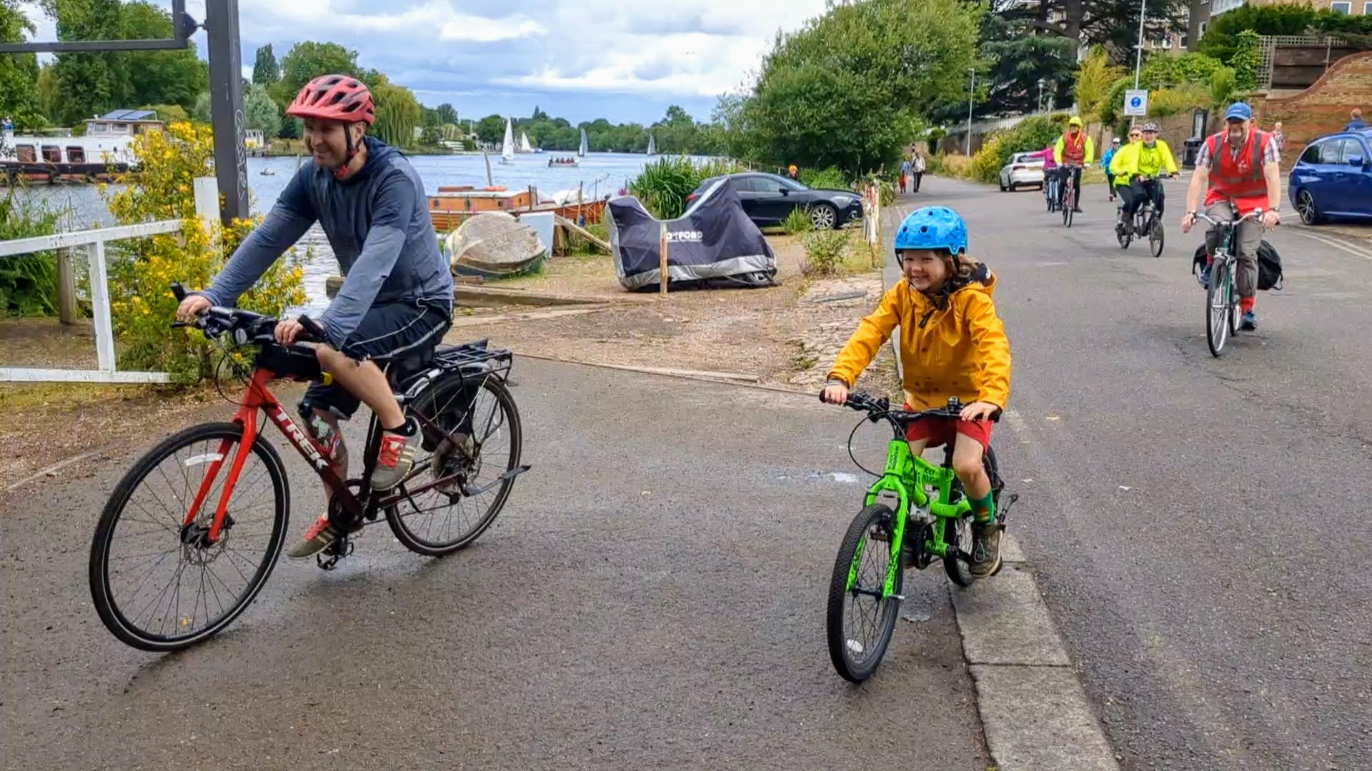
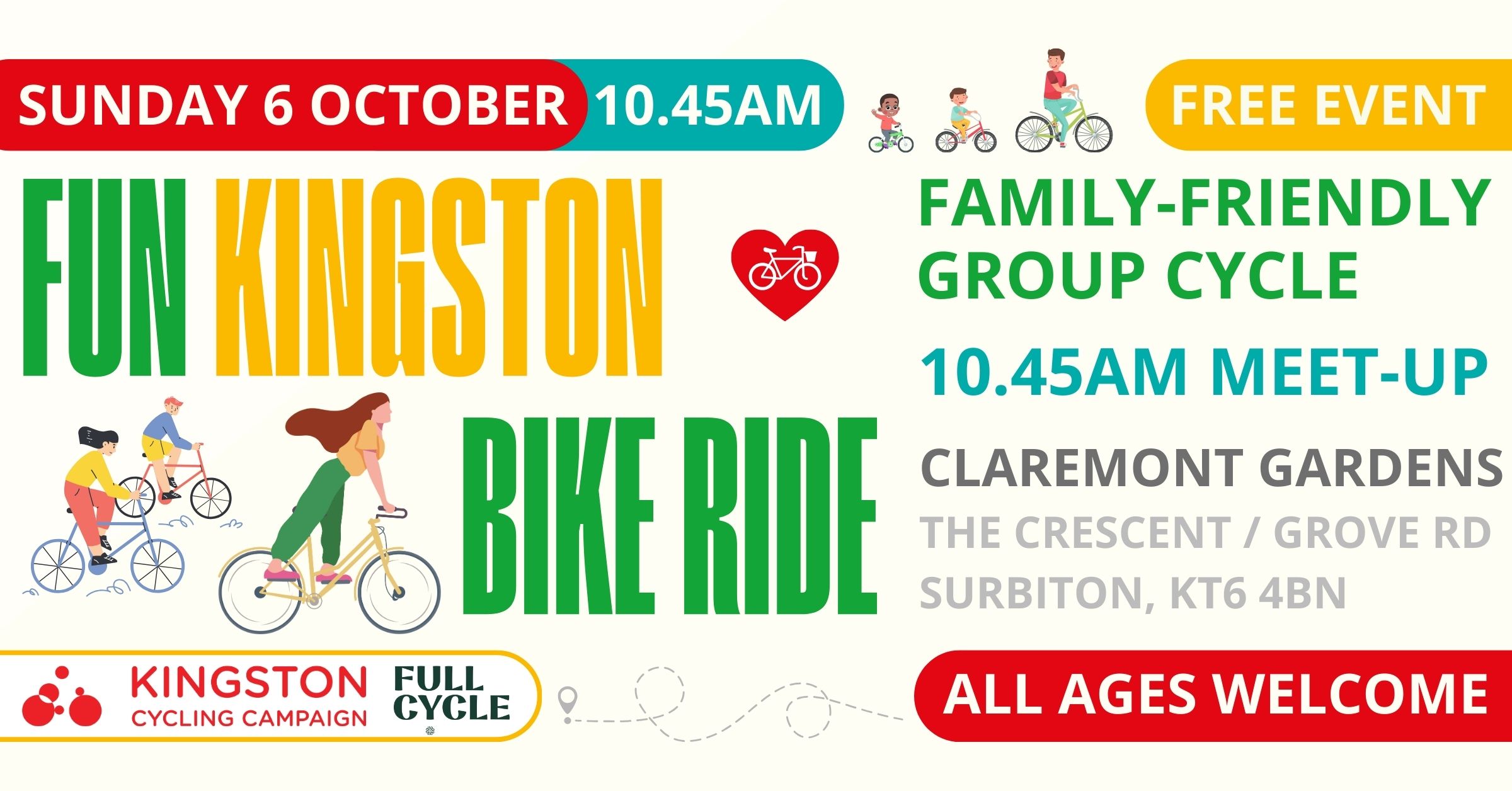
Sunday 6 October was our last family-friend ride of the year, with over a 100 riders setting off with us from Claremont Gardens, near Surbiton station. Route map on https://www.plotaroute.com/route/2701580.
Sunday 22nd September, sadly a gloomy Forecast led to 3 cancellations for Part 1. An overcast dry morning, saw 12 Cyclists, use a novel route via the Bittoms, Lower Marsh, Berrylands, Tolworth, Chessington, Claygate, Esher, -still too early, a lap of Molesey, a Pic at St Mary’s Church, as some wag remarked, ‘the Bell in Cycling, means 1 more lap’-, soon parked in the Garden of the Bell, for a delightful lunch, then Thames Ditton, Portsmouth Rd, to finish back in Kingston. Sub-total 15 Miles, thanks to Toni for back marking. Map:- www.plotaroute.com/route/1684206
Part 2. With 1 more cancellation, farewell to 4, welcome 1 more, 9 Cyclists left via Kingston Bridge, Bushy Park (Photo), Hampton, Hanworth, Hanworth Park, Leitrim Park- now with steady drizzle-, River Crane path, Kneller Gardens, Twickenham, St Margarets, to Marble Hill Park Cafe for refreshments, Twickenham riverside- where a young child suddenly rushed out from behind a parked Car, in front of our leader, a swerve to the Left, to avoid hitting the youngster, meant a tumble, luckily as it was relatively low speed, the only injury is a grazed knee & minor adjustment to 1 brake lever-, Strawberry hill, Teddington, Hampton wick, Kingston Bridge, to finish back in Kingston. Sub-total 15 Miles, Total 30 Miles, thanks to Andrea E for back marking. Map:- www.plotaroute.com/route/2760114
Wednesday 18th September, a cloudy morning, with more Sun in the afternoon, after 2 late cancellations & 1 no show, 15 Cyclists, left via Kingston Bridge, Bushy Park, Fulwell, a short bit of Crane river path, Whitton, Hounslow, Osterley, Osterley Park (Photo), Norwood Green- with a loose bag, leading to the tail end missing a turn, soon corrected (leader must make sure we are all together)-, Grand union Canal path to Hanwell for lunch at the delightful & friendly Fox, Churchfields Rec- with the viaduct just visable through the trees-, West Ealing, Hanger Hill, North Ealing, Acton, Acton Park, South Acton, Chiswick Green, Grove park, Chiswick Bridge, Mortlake, to East Sheen for refreshments at Palewell Common Cafe, Sheen gate Richmond Park, Kingston Gate, to finish back in Kingston. Total 29 Miles, thanks to Celia for back marking & Toni & John E for marking corners. Map:- www.plotaroute.com/route/786525
Wednesday 11th September. A rather chilly evening, after 2 late cancellations & 1 no show, 11 Cyclists left via the Guildhall (roadworks on 2 Roads we might use causing a novel route), Lower Marsh, Berrylands, New Malden, Motspur park- with the group split by the level crossing interupting progress-, Cannon Hill Common, Merton park, South Wimbledon for refreshments at the Sultan, -a small navigation hiccup-, Central Wimbledon, Wimbledon Chase, Raynes park, New Malden, Norbiton, to finish back in Kingston. Total 14 Miles. Thanks to Andrea E for back marking. Map:- www.plotaroute.com/route/879155
Sunday 8th September, definitely a day not to pay too much attention to the Forecast (Wet virtually all day), a bright day with a Sunny afternoon, alas a few had cancelled, so just 12 Cyclists left the Market via Kings Rd, Kingston gate Richmond Park, White lodge, Sheen gate, Mortlake, Chiswick Bridge, Grove park, Chiswick, Acton, West Acton, Park Royal, Stonebridge park, Wembley, Preston, Kenton, Belmont, to Harrow for lunch at ‘Duck in the Pond’ (Ember Inns), Harrow Weald, Headstone Manor Rec, West Harrow Rec, South Harrow, Northolt, Northala Fields (Photo), the newly complete Kensington Rd path & Roundabout, Southall, Norwood Green, Osterley Park, Osterley, Isleworth, Mogden, Twickenham- The leader must remember the Subway near Kneller Gardens, is liable to flooding after heavy rain as there was the previous Evening-, to Kneller Gardens for Tea & refreshments, Strawberry hill, Teddington, Hampton Wick, Kingston Bridge, to finish back in Kingston. Total 40 Miles, Thanks to John E for back marking. Map:- www.plotaroute.com/route/755785
Wednesday 21st August, A mostly Sunny morning, cloudier in the afternoon, after 1 cancellation, 14 Cyclists left via North Kingston, Kingston gate Richmond Park, White lodge, Roehampton Gate, Barnes Common, Putney, Putney Bridge, Fulham, Eel brook Common, Brompton Cemetery, South Kensington, a rather congested Chelsea, to pause & pose for a Photo, with some ‘special friends’, Victoria, to Pimlico for lunch at the always reliable White Swan, Vauxhall Bridge, the Oval, Stockwell, Clapham Common, Wandsworth Common, Wandsworth, a brief visit to the Wandle Trail, to Wimbledon Park for refreshments, Wimbledon, Wimbledon Chase, Raynes park, New Malden, Norbiton, to finish back in Kingston. Total 29 Miles, thanks to Toni & a little bit from Chris F for back marking. Map: www.plotaroute.com/route/2710703
Sunday 18th August, A slightly cloudy Morning, with more Sun after lunch, after 1 late booking, 20 Cyclists, split into 2 groups, leave via Portsmouth Rd, Giggshill Green- adding 1 more for group 2-, Weston Green, Esher- 1 more for group 1-, Walton, Weybridge, Brooklands Park (Photo’s), Byfleet village, Wisley, to Pyrford Lock for lunch at the Anchor (Hall & Woodhouse)- joined by 1 more for group 2 (23)-, Wanham gates, Ripley Green, Ockham, Hatchford, Cobham, Fairmile, to Claremont Lake Cafe (National Trust), for refreshments, Esher, Hinchley wood, Long Ditton, Surbiton to finish back in Kingston. Total 29 Miles, 3 new faces, special thanks to Bai for leading group 2, thanks to Steve D & Andrea E for back marking each group. Map:- www.plotaroute.com/route/2313436
Wednesday 14th August, a rather sultry Evening saw a round Dozen Cyclists leave via Skerne Rd, Latchmere, Ham gate Richmond Park- joined by 1 more (13)-, Petersham gate, Richmond, Richmond Bridge, St Margerets, Isleworth, Whitton, to Twickenham for refreshments at the ‘Sussex Arms (Big Smoke), Strawberry hill, Teddington, Hampton Wick, Kingston Bridge to finish back in Kingston. Total 12 Miles, thanks to Jon White for back marking.
Sunday 4th August, a largely Sunny warm day, after 1 late cancellation, 1 person unable to unlock their Bike, with 1 unexpected guest, 22 Cyclists split into 2 groups, from the Fountain, New Malden, via Motspur park, North Cheam, Pyl Brook path, Sutton, the Wrythe, Hackbridge, Beddington Park, Beddington, Croydon- with 1 of group 1 mis-timing crossing the Tram track, suffering a tumble, a quick check all was OK & a minor adjustment to straighten the handlebars-, Selhurst, Heavers Meadow, Woodside, Ashburton Field, Shirley, West Wickham, Coney hall, Keston, to Downe for a very enjoyable lunch at the delightful Queens Head- with a rendiition of ‘When that I was’, then a short detour to Down House, home of Charles Darwin-, (Photo), a long gentle descent to High Elms, Farnborough, Orpington, Crofton, Southborough, Norman Park, Bromley, to Beckenham for Tea & refreshments at Kelsey Park Cafe, a short walk through the Park to enjoy the Scenery, Elmers end, South Norwood Country Park, South Norwood, Heavers Meadow, Thornton heath, Pollards Hill, Mitcham, Morden Hall Park, Merton park, Wimbledon Chase, Raynes park, to finish back in New Malden. 45 Miles, 1 new face, special thanks to Bai for leading group 2, thanks to Chris F & Amy for back marking each group, thanks to Nigel & Will for the musical interlude. Map:- www.plotaroute.com/route/2152617
Sunday 28th July, a gorgeous Sunny day, with 1 late cancellation & 1 unannounced guest, 16 Cyclists left via Kingston Bridge, Bushy Park, Hampton, Hanworth, Sunbury- with a touch of wheels, 1 cyclist suffered a fall, after a quick check, swiftly remounted-, Ashford, Stanwell, Stanwell moor, Poyle, Harmondsworth Moor, to Harmondsworth for a split lunch, some at the Five Bells, the majority at the Crown, then a visit to the Great Barn, back on the Bikes, Sipson, Harlington, Hayes, to join the Grand Union Canal towpath, Southall, Norwood Green, to Osterley Park for refreshments, at the Stables Cafe, also a Photo before leaving the Park, Osterley, Hounslow, Whitton, Twickenham, Strawberry hill, Teddington, Hampton Wick, Kingston Bridge to finish back in Kingston. Total 30 Miles, 1 new face, thanks to John E for back marking & others for watching corners. Map :- www.plotaroute.com/route/840250
Wednesday 24th July, a largely bright, somewhat humid day saw 16 Cyclists, split into 2 groups, no wait, 1 extra unannounced guest wants to join group 2, leave via Portsmouth Rd, Long Ditton, joined by 1 more for group 1, Hinchley wood, Esher, 1 more for group 2- total 19-, Fairmile, Cobham, Hatchford, Ockham, to West Horsley, to find the Pub not yet open, we’re ‘Twirlies’ – a term some here when trying to use a Bus Pass, ‘too early‘- , soon we found the landlord, so lunch at the Barley Mow, even though a couple of food orders did need chasing, East Horsley, Horsley Common, Effingham, Bookham, Fetcham & Pond (Photo group 1), Leatherhead, Ashtead,- almost losing group 1 back marker-, Ashtead Park, Woodcote, Rosebury Park, Epsom, to Alexandra Park, only to find the intended Tea stop had gone on holiday this very day, a quick discussion, group 2 settled on a Tea stop in Ewell village, group 1 continued, West Ewell, Hogsmill Park, to Court Farm Garden centre Cafe, for there Tea stop, Tolworth, Surbiton, to finish back in Kingston. Total 33 Miles, special thanks to Nigel for leading group 2, thanks to Dave P & Toni for back marking each group. Map:-www.plotaroute.com/route/1508730
Wednesday 17th July, a mostly Sunny evening, after 2 late cancellations, just 7 Cyclists left via Lower Marsh, Berrylands, New Malden, Malden Manor, Cuddington, Auriol Park, Stoneleigh- with a small Road rage incident, thanks to Christine for standing up to the driver-, Nonsuch Park, East Ewell, to Ewell Village for refreshments at the Wheatsheaf,- although we arrived just after the Clarencourt off Road group, we managed to beat most of them to the Bar, West Ewell, Tolworth, Surbiton, to finish back in Kingston. Total 13 Miles, thanks to John E for back marking.. Map:- www.plotaroute.com/route/2318838
Sunday 14th July, a largely bright day, with splashes of Sun, saw 23 Cyclists gather at Blackfriars Station, having mostly travelled on Thameslink from Wimbledon, split into 2 groups, follow Cycleway 6 (C6), to Farringdon, Islington, then C27, De Beauvoir town, London Fields (Photo group 2), ‘Well Street Common’, Victoria Park, Hackney Wick, Queen Elizabeth Olympic Park, River Lea navigation Towpath, Leyton Marsh, (Group 2 with a small sat-nav hiccup), Walthamstow Wetllands, to the edge of Tottenham for lunch at the Ferry Boat Inn (Stonnegate pubs), Tottenham Hale, Haringey, Downhills Park, Wood green (Group 1 navigation hiccup), Alexandra Park (Photo group 1), Parkland Walk (North), Muswell Hill, East Finchley, Hampstead Garden Suburb, Golders green, West Hampstead, Brondesbury, to Queens Park for Tea & refreshments, Kensal town, Ladbroke grove, Shepherds bush, Hammersmith, a dismount to walk across Hammersmith Bridge, Barnes, Richmond Park, Ham gate, Latchmere, to finish back in Kingston (much to 1 persons surprise). Total 35 Miles, 1 new face, special thanks to Bai for leading group 2, thanks to Steph & Ellie for back marking each group. Map:- www.plotaroute.com/route/2684884
On Sunday 7 July riders of all ages gathered at the Canbury Gardens bandstand for a lovely relaxed ride through Richmond Park and back along the river, with the Canbury Gardens Safer Neighbourhood Team on hand for free bike marking before and after the ride to help everyone keep their bike safe. Route map on http://www.plotaroute.com/route/2614506.
Sunday 23rd June. Part 1. A bright Sunny Morning with 1 late booking, 1 late cancellation & 1 unannounced guest, 18 Cyclists- no wait, 1 person tried following a different group, Kingston Wheelers? Despite the valiant efforts of the back marker, he couldn’t be caught-, so 17 left via Kingston Bridge, Bushy Park, Hampton- pausing to visit the Memorial to General Roy, ‘Grandfather of the Ordenance Survey’-, (Photo), Hanworth, Hanworth Park, Leitrim Park, River Crane path, Kneller Gdns to Twickenham for lunch at the Prince Blucher (Fullers), also joined by the ‘lost Sheep’ (18), Strawberry hill, Teddington, Hampton Wick, Kingston Bridge to finish back in Kingston. Sub-total 14 Miles, special thanks to Andrea for back marking & attempting to recover the lost sheep. Map:- www.plotaroute.com/route/528789
Part 2, still warm, but mostly cloudy afternoon, saying farewell to 6 Cyclists, welcome to 3 more, plus 1 more unannounced guest, 16 Cyclists left a rather busy Market place, via Skerne Rd, Latchmere, Ham gate Richmond Park, Pen Ponds (Photo), Roehampton gate, Roehampton, Putney Heath, Wimbledon Common, for refreshments at the Windmill Tea rooms, Crooked Billet, Raynes park, New Malden, Norbiton, to finish back in Kingston. Sub-total 14 Miles, thanks to John E for back marking, Total mileage 28 Miles Map:-www.plotaroute.com/route/632080
Wednesday 19th June. With 1 late cancellation, 1 late booking, & 1 no show, a bright Sunny evening, 17 Cyclists left via Kingston Bridge, Bushy Park, Fulwell, Twickenham, Twickenham Railway path, Cole park, St Margarets, Richmond Bridge, to Richmond Hill for refreshments at the delightful, if rather busy Roebuck, also meeting several other LCC groups, (Photo), to see the dying of the Sun (the nearest Weds to the Summer solstice), also joined by 1 more (18), Richmond Park, to Kingston gate, to finish back in Kingston. Total 11 Miles, thanks to Chris F for back marking. Map:- www.plotaroute.com/route/1588396
Wednesday 12th June, Flaming June, I don’t think so, a rather chilly overcast day, with 1 cancellation, & 1 unexpected Guest, left via Portsmouth Rd, Long Ditton- joined by 1 more (15), Giggshill Green, Weston Green, Esher- with work in progress on the Weir gate, a short dismount to walk past the obstruction, Walton, Weybridge, Addlestone, to visit the ‘Crouch Oak’ (Photo), a splendid ancient tree, circa 800 years old, reputedly Queen Elizabeth I enjoyed a picnic under the tree, now supported by some Ironwork, closing 1 of the traffic lanes, a novel ‘Low traffic neighbourhood’ me thinks, Bretlands, to Lyne for lunch at the ‘Royal Marine’, then Thorpe Green, Stroude, Egham, Staines Bridge, Staines, Ashford, Sunbury, Feltham, Hanworth, Hampton, Bushy Park, for refreshments at the Pheasantry- with new much more Cyclist friendly gates-, Hampton Wick, Kingston Bridge, to finish back in Kingston. Total 31 Miles, thanks to Chris F for back marking, & others for marking corners. Map:- www.plotaroute.com/route/1049116
Sunday 9th June. A Bright sunny morning, with more cloud in the afternoon, after 1 late cancellation, 23 Cyclists, split into 2 groups, leaving via Fairfield, Norbiton, New Malden, Raynes park, Wimbledon chase, Merton park, Morden Hall Park (Photo 1 & 2), the simply splendid Wandle trail including Ravensbury Park, Mitcham & Hackbridge to Carshalton, continuing on NCN 20, Little Woodcote, to Woodmansterne, for lunch at the Woodman (Stonegate Pubs),- then with One of group 1 needing a little more Air in a Tyre, group 2 took the lead-, Banstead, -Group 1 almost snatching the lead back. Burgh heath, Tattenham corner, Epsom, Epsom Common, to the Old Moat Garden centre Cafe for refreshments, Manor park, Long Grove Park, St Ebba’s path, a brief bit of Hogsmill path, West Ewell, Tolworth- with a touch of Wheels, causing a fall, thankfully no lasting damage-, Berrylands, to finish back in Kingston. Total 29 Miles, Special thanks to Bai for leading group 2, thanks to Amy & Ellie for back marking each group. Map:- www.plotaroute.com/route/623630
Wednesday 22nd May, A rather damp drizzly evening, not a surprise that 5 of the 9 who had booked, decided to cancel, so just 4 hardy souls left via the Fairfield, London Rd track, North Kingston, Tudor Estate, Ham, Teddington Footbridge, Teddington, Hampton Hill, Hampton- with a lost screw on 1 rack, causing a short pause-, to find the intended stop, the Railway Bell has ‘closed until further notice’ , so onward to the Jolly Coopers for refreshment, then Bushy Park- with a full Moon for company-, but alas a visit from the ‘P fairy’ for our leader, despite insisting the others should all continue, 2 rightly did, but the Back marker, insisting he would stay to give some illumination- Thank-you John, with a stubborn shard of glass, a not so speedy repair, eventually back on the road, Hampton Wick, Kingston Bridge, to finish back in Kingston. Total 12 Miles, very special thanks to John E for back marking. Map www.plotaroute.com/route/1872658
Sunday 19th May, a mostly Sunny day with 1 extra unbooked person a total of 20 Cyclists left via the Portsmouth Rd track, Giggshill Green, Weston Green, Esher, Walton, Weybridge, Brooklands Park (Photo), West Byfleet, New Haw, Rowtown, to Addlestone for lunch at the very friendly Pelican, next to the Wey Navigation- with a couple of Swans showing off their young family-, now joined by 1 more it was decided to split into 2 groups, via Chertsey Meads, Chertsey Bridge, Dockett Eddy Lane, Shepperton, Haliford, to Lower Sunbury for Tea & refreshments at the Walled garden, Sunbury, Hampton, Bushy Park, Hampton Wick, Kingston Bridge, to finish back in Kingston. Total 30 Miles, sppecial thanks to Bai for leading group 2, thanks to Toni & Celia for back marking each group & others for marking corners. Map:- www.plotaroute.com/route/966549
Wednesday 15th May. A mostly cloudy morning, with much more Sun in the Afternoon, with 1 late booking, 15 Cyclists left New Malden via the Beeline, Raynes park, South Wimbledon, Colliers wood, Tooting- joined by 1 more (16)-, Tooting Bec Common, Streatham Hill, Tulse Hill, Brockwell Park, Loughborough, Camberwell, Burgess Park- pausing briefly to chat to Sustrans-, to join C10 via South Bermondsey, back of Millwall FC, Folkestone Gardens, to Deptford for lunch at the Dog & Bell, then a fairly new C4, NCN425, Greenland Dock, & Russia Dock woodland (former Surrey Docks, a real delight), Rotherhithe, & the Brunel Museum, a brief visit to the Thames Path, Bermondsey, Potters Field- near Tower Bridge, only to find the intended sculpture for the backdrop to our Photo has been moved (see before & after below), the Borough, Waterloo, Lambeth, the Oval. Clapham Common, to Wandsworth Common for refreshments at ‘the Skylark Cafe’, Earlsfield, Wandle trail, Wimbledon, Wimbledon Chase, Raynes Park, to finish back in New Malden. Total 33 Miles, thanks to Ellie for back marking & others for marking corner. Map:- www.plotaroute.com/route/2532828
Sunday 12th May A bright mostly Sunny day, after 1 late cancellation, 17 Cyclists met at Tolworth Station, go via West Ewell, Epsom- joined by 1 more- (18), Woodcote, Langley vale, – a little bit of confusion with a different route-, Headley, Pebblecombe, Betchworth, (Photo), Strood Green, Shellwood Cross, to Parkgate for lunch at the delightful Surrey Oaks, Newdigate, Henfold, Blackbrook, North Holmwood, Dorking, Meadowbank Rec, A24 Cycle track, Norbury Park farm, to Bocketts Farm for Tea & refreshments, Leatherhead, Ashtead, Ashtead Common, Epsom Common, Horton Country Park, Bonesgate Path, to finish back in Tolworth. Total 40 Miles, thanks to John E for back marking, thanks to Steve D & Mike F for marking corners. Map:- www.plotaroute.com/route/440364
Sunday 28 April, this confidence-building ride set off from Victoria Recreation Ground, allowing us to explore quiet roads in Surbiton, Long Ditton and Berrylands. Watch our 30-second montage here and recreate the route via this map: http://www.plotaroute.com/route/2497588.
Wednesday 24th April. A rather chilly evening, make that just COLD, after 2 late cancellations, 9 Cyclists left via Cranes park, Surbiton, Long Ditton, Hinchley wood, Littleworth Common, Esher to Molesey for refreshments at the Bell, Thames Ditton- with a surprise encounter with another regular, on her way home-, Portsmouth Rd, to finish back in Kingston. Thanks to John E for back marking. Map:-www.plotaroute.com/route/1207451
Sunday 21st April. A mostly cloudy day, with patches of Sun, with a chilly Head wind, after 2 late cancellations, saw 19 Cyclists split into 2 groups, leave via Skerne Rd, Latchmere, Ham gate Richmond Park, White Lodge, Roehampton gate, Barnes Common, Putney, Putney Bridge- joined by 1 more (20)-,Fulham, Brompton Cemetery, South Kensington, Kensington Gardens, Hyde Park (Photo group 1), Marylebone, to Maida Vale for lunch at the charming Carlton Tavern rebuilt , Kilburn, Westbourne Park, North Kensington, Shepherds Bush, Hammersmith, Hammersmith Bridge (Photo group 2), Barnes, East Sheen, to Palewell Common, only to find the Cafe had shut early, so waiting briefly for group 2, then Sheen Gate, to the Pen Ponds Cafe for refreshments, Ham Cross, Kingston Gate, to finish back in Kingston. Total 29 Miles, special thanks to Bai for leading group 2, thanks to Ellie & Chris F for back marking each group. Map:- www.plotaroute.com/route/2162317
Wednesday 17th April A mostly cloudy day with some Sun & a blustery Wind, saw 18 Cyclists leave the Market place via Lower Marsh, Berrylands, Tolworth & the Greenway- extension to Tolworth Station almost ready by the look of things-, West Ewell- joined by 1 more (19)-, Horton, Ashtead Common, Leatherhead, Fetcham, Bookham, to Effingham for lunch at ‘the Queen Stage’, (a Cycling term for the toughest stage in a long multi day Cycle race), Effingham Junction, Martyr’s green, Hatchford, Cobham, Fairmile estate (Photo), Portsmouth Rd, to Claremont Lakes Cafe (National trust) for refreshments, Esher, Hinchley wood, Long Ditton, Surbiton to finish back in Kingston. Total 28 Miles, thanks to Toni for back marking & several others for marking corners. Map:- www.plotaroute.com/route/523447
Sunday 7th April. A bright largely Sunny day, with a strong blustery wind, after 2 no shows, & 1 very late booking saw 24 Cyclists split into 2 groups, leave via Kingston Bridge, Bushy Park, Hampton, Lower Sunbury, Haliford, Shepperton, Laleham, Staines, Staines Bridge, Egham, Englefield Green, Bishops gate of Windsor Great Park, the Village (Photo group 1), Rangers Gate, Spital Meadow, Windsor, to Eton for lunch at the Watermans Arms, -alas group 1 losing touch with with One of the party-, the Brocas, a brief visit to the Jubilee River path, Datchet, Wraysbury, Hythe end, to Lammas Park for Tea & refreshments, Staines, Ashford, Feltham, Hanworth, Hampton, Bushy Park, Hampton Wick, Kingston Bridge to finish back in Kingston. Total 41 Miles, 2 new faces, Special thanks to Steve F for leading group 2, thanks to Celia & John E for back marking each group. Map:- www.plotaroute.com/route/530830
Sunday 24th March Part 1. A mostly bright day, with a slightly chilly wind, after 4 late cancellations, saw 18 Cyclists leave via Portsmouth Rd, Long Ditton, Hinchley wood, Littleworth Common, Esher, Walton, Walton Bridge, Shepperton, Haliford, to Sunbury for a superb lunch at the ‘Flower Pot (Brakspear), more Sunbury, Hampton, Bushy Park (Photo), Kingston Bridge to finish back in Kingston. Sub-total 17 Miles, Thanks to Steve F for back marking, thanks to Bai for leading a couple of sections. Map:- http://www.plotaroute.com/route/2551761
Part 2 Saying farewell to 11 welcome to just 1 fresh face, 8 Cyclists leave via Lower Marsh, Berrylands, New Malden, Malden Manor, Cuddington, Nonsuch Park, East Ewell, Nescot path, to Alexandra Park for refreshments at Park view Cafe, Ewell village, West Ewell, Tolworth, Surbiton to finish back in Kingston. Sub-total 15 Miles, Total 32 Miles. Thanks to John E for back marking. Map:- www.plotaroute.com/route/2559381
Wednesday 13th March. A dry & cloudy day, with a mostly useful tailwind on the outward journey, saw 13 Cyclists leave New Malden on the Beeline, Raynes park, Wimbledon chase, South Wimbledon, Colliers wood, Tooting- joined by 1 more (14)-, Streatham, Norbury, Thornton heath, -with 1 motorist upset that we were using the ‘contra flow cycle lane’-, Heavers Meadow (with the entrance from Selhurst Rd a mudbath), Woodside, Ashburton Field, Shirley, Elmers end, Eden park, to West Wickham for lunch at the Railway (Ember Inns), more Shirley, Addiscombe, Lloyd Park (Photo), South Croydon- with a jammed chain needing some delicate adjustment-, Waddon, Richmond Green, Beddington Park, to Carshalton for Tea & refreshments at ‘Sassis in the Grove, – with 1 member suffering a visit from the ‘P Fairy’-, the Wrythe, Benhill, Pyl Brook path, North Cheam, Motspur park, to finish back in New Malden. Total 31 Miles, thanks to Chris F for back marking. Map:- www.plotaroute.com/route/1579827
Sunday 3rd March. With London Cycling Campaign’s second Women’s Freedom Ride coinciding with our planned leisurely ride, we decided to run a feeder ride to lend our borough’s support in the run up to International Women’s Day. In addition to pick-up points from Kingston (market place) and New Malden (station), we arranged a third meet-up point in Wimbledon (Garfield Recreation Ground) to help our counterparts from Merton Cycling Campaign join the main ride too. This unusual departure from our normal weekend rides was supported by the weather Gods, with sunshine warming up the chilly day. Our first group – with over 20 cyclists – was led by Bai as it left the market place via Fairfield and Norbiton to join our second group (led by Roger) in New Malden. Here we picked up a further 11 cyclists and stayed as one group down the Beeline Way to Raynes park, wending our way via the back streets of Wimbledon Chase and South Wimbledon to meet our Merton counterparts of 10 cyclists. From here we took the Wandle trail via Earlsfield and Wandsworth Common where we split into 2 groups again for the final journey to the main ride in Lincoln’s Inn Field, riding via Clapham Common, Stockwell, the Oval, Lambeth, Waterloo and Blackfriars Bridge, The Women’s Freedom protest event itself attracted over 800 people, with women and allies from all across London gathering to call on the Mayor to remove barriers to women cycling in London. After a few short speeches, and the presentation of a 5000+ signature petition to Will Norman (London’s Walking & Cycling Commissioner) demanding action to make the capital’s streets safer for women and girls, we set off. Despite a slow start leaving London’s largest public square, due to the incredible turn-out of supporters, the high-energy ride soon took in some of London’s best-known landmarks, with music bikes dotted throughout to keep the good vibes flowing. From Oxford Street and Regent Street through Piccadilly Circus, down Pall Mall, around St James’s Park, along Whitehall to Trafalgar Square and back to the starting point via The Strand and Covent Garden, riders waved their flags and placards as they passed Buckingham Palace, the Houses of Parliament and 10 Downing Street.
Despite our best intentions, the unpredictable nature of protest rides made the departure time of the return ride a little tricky to pin down. With some of the marshals who had opted out of the freedom ride to refuel at the nearby Penderel’s Oak (Wetherspoons) anxious to return to Kingston, the group left the agreed meeting point in Lincoln’s Inn Field and headed for the Strand in the hope of intercepting some of our group. Whilst some of the pub party continued home on their own return journey, a stalwart few waited for the rest of the Kingston crew, including one marshal kindly returning to the original meeting point to round-up the final riders.
Once reunited, a group of 15 set off from the Strand via St James, Green Park, Hyde Park, South Kensington, Brompton Cemetery, Fulham, Parsons Green, Putney Bridge, Putney, Barnes Common, Roehampton Gate, Richmond Park, White lodge and Kingston Gate before finishing back in Kingston Market Place – 38 miles, including the Women’s Freedom Ride. And just one slipped chain to report between everyone. Maop:- http://www.plotaroute.com/route/2480632
Sunday 18th February, with a ‘Yellow weather warning for Rain’ & Network rail deciding belatedly that they needed to cancel all trains via Wimbledon, not too surprising that 8 cancelled, yet 18 Cyclists did gather for a largely sunny day, so via Surbiton, Long Ditton, Hinchley wood, Esher, Fairmile, -a newly completed Cycle path in Cobham, Downside -a few Puddles & some residual mud on Plough Lane-, Hatchford, Ockham, to Ripley for lunch at the Jovial Sailor (Baron Pubs)- joined by 1 more for lunch (a late starter), & 1 more after lunch (20), Send Marsh (almost a missed turn), Newark Priory (Photo), Pyrford Lock, Muddy lane- sadly lived up to it’s name, Byfleet, Brooklands park- having to weave through the Funfair-, a little more mud, Weybridge, Walton, Esher, Weston Green, Giggshill green, Portsmouth Rd, to Surbiton for Tea & refreshments at a new venue ‘Ex Cellar’ Cafe, to finish back in Kingston. 32 Miles, Special thanks to Bai for leading & for wisely going with Plough lane, thanks to Celia for back marking & others for marking corners. Map:- www.plotaroute.com/route/1557141
Wednesday 14th February, after 1 late cancellation, with some light drizzle to start & a strong Headwind for a large part of the Morning, 20 Cyclists left via Portsmouth Rd, Long Ditton, Hinchley wood, Esher, Fairmile, Cobham, Downside, Bookham Common- with a minor navigation hiccup, leading to a different part of the Common-, Fetcham, Leatherhead,to Ashtead for lunch at ‘the Woodman’ (Ember Inns), Ashtead Park, Woodcote, Epsom, ‘Nescot path’. East Ewell, Nonsuch Park (Photo), to Cheam Park for Tea & refreshments, North Cheam, Motspur park, New Malden, Berrylands, to finish back in Kingston. Total 31 Miles, thanks to John E for back marking & sevaral others for marking corners. Map:- www.plotaroute.com/route/312617
Sunday 4th February. A mostly cloudy day, after 4 late cancellations, 19 Cyclists split into 2 groups, via Lower Marsh, Berrylands, New Malden, Motspur park, North Cheam, Pyl brook path, Benhilton, Carshalton- group 1 joined by 1 more-, Wallington, Waddon, South Croydon, Sanderstead (Photo group 2), Hamsey Green, Warlingham to Old Farleigh for lunch at ‘the Harrow’ (very hospitable), -with some very light drizzle, having fallen during lunch-, Chelsham, Fickleshole, Long shaw, where the group 1 leader sadly hit a greasy spot, tumbling to the ground, fortunately we did have a Nurse with us who made doubley sure nothing was broken, thankfully aside from a few bruises & grazes, all was fine, -although my front light was now hanging loose-, but decided to ask group 2 leader to lead the whole group home, Coney Hall (Photo group 1), West Wickham, Shirley, Ashburton field, Woodside, Heavers Meadow, Thornton heath, Pollards hill, Mitcham, Morden Hall Park- now too late for a Tea stop, Merton park, Wimbledon Chase, Raynes park, Beeline & the Cut, Mount pleasant, Norbiton, to finish back in Kingston. Total 42 Miles, very special thanks to Bai for leading group 2 & later the whole the whole party, thanks to Chris F & Steve F for back marking each group, thanks to Bai & Steve for marshalling traffic during the ‘incident’, thanks to Lindsay for nursing duties. Casualty update; I’m pleased to say no more than the bruises & grazes mentioned earlier Map:- www.plotaroute.com/route/821611
A rather breezy day, Dry & a lot warmer than of late. With 4 late cancellations & 2 no shows, it was not the record number for a January ride that might have been, still 22 Cyclists split into 2 groups, left via Piortsmouth Rd, Giggshill green- collecting 1 more for group 1-, Weston Green, Esher, Walton on Thames- with a visit from the ‘P Fairy’ for group 1, thus group 2 took the lead-, Walton Bridge, Shepperton, Chertsey Bridge, Chertsey, Thorpe- with a 2nd visit from the ‘P fairy’, this time for an E bike, without the know-how, to remove the rear Wheel, the victim had a long walk to Staines for a Train Egham Hythe, Staines Bridge, to Staines for lunch at the rather busy George (Wetherspoons), -swiftly served all the same-, with a much stronger Wind, but mostly from behind, Knowle Green, Ashford, Sunbury, Hanworth, Hampton, to Bushy Park- with group 2 (still in the lead), deciding to forego a Tea stop, thus a rather early finish, group 1 did stop at the Pheasantry for Tea & refreshments-, Hampton Wick, Kingston Bridge, to finish back in Kingston. Total 28 Miles, 2 new faces, special thanks to Bai for leading group 2, thanks to Toni & Steve D for back marking each group, 2 visits from the ‘P fairy’. Map:- www.plotaroute.com/route/2348333
Wednesday 17th January. After a freezing cold night, how many would be brave (or even foolhardy) enough to ride, & would it be safe ? A quick pre amble on local Roads, with no Ice to be seen, I decided we should be OK to go, after 10 cancellations, 6 brave Cyclists left via Fairfield, the London Rd track, Norbiton, Kingston gate of Richmond Park, to Sheen gate, Motlake, the first of 4 level crossings, set the trend, -at least a 3 Minute wait at each, Chiswick Bridge, Grove park (2nd crossing), Chiswick Green, Acton (3rd & 4th crossing), Ealing Common, North Ealing, Pitshanger Park, Perivale, Medway village, – a missed turn, not quite hiding in plain site-, Greenford, to Northolt for lunch at ‘the Greenwood Hotel (Wetherspoons), (and a delightful Art Deco interior), -a very congested A312, Petts Hill, due to HS2 work-, Northolt Village, then a more pleasant surprise, a new Cycle path, still under construction, but 1/2 Mile already usable, Southall, Norwood Green, Osterley Park (Photo)- with Ducks & other water birds doing some Ice dancing in the background-, Osterley, Hounslow, Whitton, to Kneller Gardens for Tea & refreshments, Strawberry hill, Teddington, Hampton wick, Kingston Bridge, to finish back in Kingston. Total 30 Miles, special thanks to John E for back marking. Map:- www.plotaroute.com/route/909611
Sunday 14 January, the first family-friendly ride of the year, with the Mayor on hand to cheer us on from Surbiton’s Alexandra Park / Recreation Ground- full info here, and map route on https://www.plotaroute.com/route/2391953.
Sunday 7th January, after 1 late booking & 1 cancellation, with a bright Sunny morning, mostly cloud after lunch, the first ride of 2024 set off from New Malden with 20 Cyclists, via Raynes park, South Wimbledon, the Wandle trail – collecting 1 more-, Earlsfield, Wandsworth Common, Clapham Common- suddenly with an icy headwind-, Stockwell, the Oval, Vauxhall, Vauxhall Bridge, to Pimlico for lunch at ‘the White Swan’ (McMullens), then Wesdtminster (Photo), CS3, Southwark Bridge, Bermondsey, CS14, CS10, Burgess Park, Camberwell, Loughborough, Brockwell Park, -where the hoped for indoor Cafe, was closed for a refit, so Al-fresco Tea stop & No Bread pudding-, Tulse Hill, Streatham Hill, Tooting Bec Common, Tooting, Myrna Gardens, Colliers wood, a bit more Wandle trail, Morden Hall Park, Merton park, Cannon hill Common, Motspur park to finish back in New Malden. Total 31 Miles, thanks to Chris & John E for back marking & others for marking corners. Map:- www.plotaroute.com/route/933539.